
Senan
Senan is a small town of approximately 50 inhabitants in the comarca of Conca de Barberà in the province of Tarragona in Catalonia, Spain. The Gaussen diagram shows the climate, which defined as a cold, semi-arid climate (BSk) by the Köppen-Geiger system, and it is characterized by a 4-month summer drought. Total annual precipitation is 400 mm on average, the majority of which occurs in the spring and fall.
Senan (650 masl) is located the in Serra del Tallat, a small mountain range in the Catalan Central Depression. From the high ridge, the mountains slope steeply southeast, forming one edge of the Conca de Barberà. In the other direction, the terrain descends gently to the plains of Lleida to the northwest. This territory is carved by series of nearly parallel valleys draining towards the plain. Senan is located near the top of one of these valleys, the Fondo dels Pouets. Erosion during storms formed the valleys, but since annual precipitation is low, there are no visible streams or rivers.
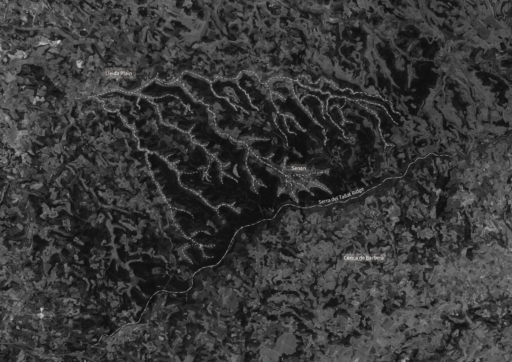
The surrounding area is primarily agricultural, producing grains, olives, almonds and some grapes for wine. Cereal grains are grown in accessible areas with shallow slopes, usually located along the floor of the valleys where the soils are richer. Where access is difficult and the slopes are steeper, people often plant olive or almond orchards. Extensive (and likely more commercially viable) plantations of almonds and olives also occur in large and flat parcels in the valley bottoms. The ridges and steep slopes host pine plantations. Stone walls weave through the landscape, terracing the valley slopes as they descend toward the plain of Lleida and the slopes perpendicular to the valleys. Called marges in Catalan, these stone walls are indeed a marginal condition within the larger productive landscape, located at the border between two fields. These walls, built over generations in response to the topography, host a diverse ecology of plants and insects. Many of the walls are in disrepair since it requires both time and skill to keep them in good condition. Completing the mosaic are the steepest slopes, which were likely never farmed, and fields that were abandoned and have since succeeded to forest.
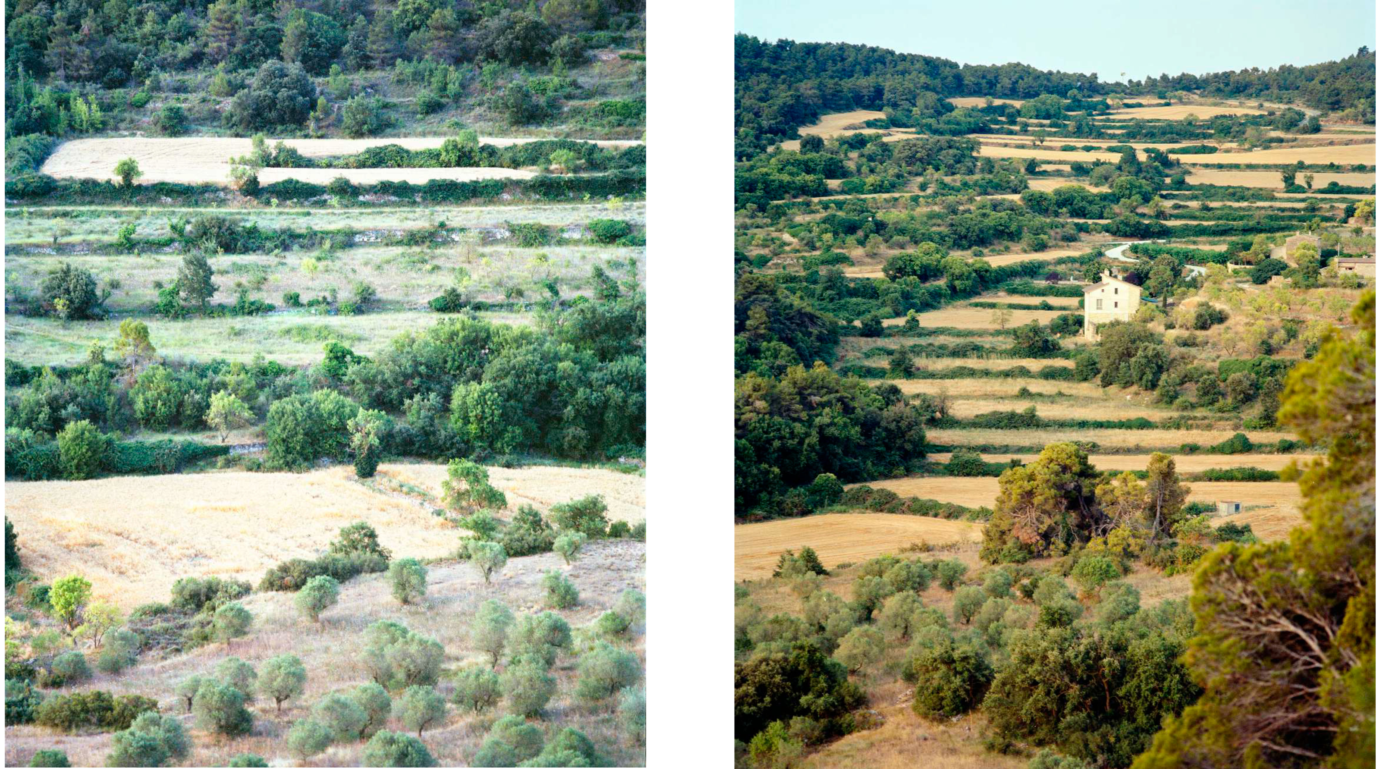
In the past the area that people farmed was much greater then today, reflecting a shift in economy of this rural landscape as well as changes in farming technology. The tractors and machines necessary for economically viable contemporary agriculture cannot access many of the fields since the walls supporting them were constructed at a time when farming was done by hand and with animals. Since the first third of 1900 and till nowadays, the forest surface in Catalunya has been constantly increasing. What in 1955 was estimated as a 40% of forest surface (Schwarzlmüller, 2008 in Cervera et al., 2015), in 2020 has reached more than a 60% of the total coverage of the land in the region.

A walk in a seemingly ancient forest reveals stone walls identical to the ones supporting the terraced fields in the valleys. These hidden walls testify to the maximum extent of cultivation, which reaches far into the forest of today. As it became economically viable to farm only the flattest and largest fields in the valley bottoms, the upper fields were abandoned and the forest has expanded steadily. While the cultivated area has decreased, the exploitation of the remaining fields has intensified through the help of modern agricultural technologies.
This dynamic might chiefly respond to two factors: first, the massive deforestation that took place during the 20th century in order to increase the tillable surface, and the succeeding policies of reforestation in the earlies 1900; and second, ongoing demographic changes, beginning in the 1950s, that result in a decreasing rural population and subsequent abandonment of a substantial portion of the previously cultivated fields.
After stopping their management, the land begins a process of development guided by the dynamics of the site, where climate and soil work along with the early successional vegetation. This ever-changing situation tends, through succession, to evolve towards being a forest.


